Giveaways
(If you haven’t already read Part 1 of this two-part series, it is here.)
EASTWARD from Lake Clearwater, you return to the Canterbury Plains by way of the Ashburton Gorge Road as far as the town of Mount Somers, where there is an old-fashioned general store.

The town of Mount Somers began its existence as a camp for miners digging outcrops of coal from the flanks of the physical Mount Somers; a peak on the northern side of the entrance to the Ashburton Gorge through which the Hakatere area is accessed from Canterbury.
Mount Somers (the mountain) has been known for much longer, in Māori, as Te Kieke. Both names celebrate individuals who played a hand in the founding of their respective communities here: the British politician Thomas Somers-Cocks who was a sponsor of the Canterbury settlers on the European side and Te Kiekie, a founding chief of the Māori who arrived in one of the first voyaging-canoes from island Polynesia. It’s an interesting parallelism, I think.
The town was established in the days when the larger West Coast coalfields had not yet been tapped, and when there was in any case as yet no way of getting the coal through to Canterbury. Clay, sand, and limestone were also mined locally.
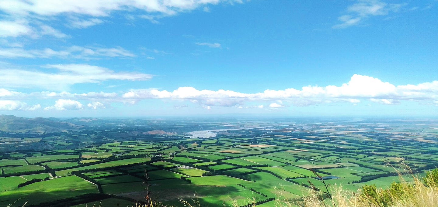
From the town of Mt Somers, you head north to Staveley to gain access to the tracks up the east side of Mount Somers/Te Kiekie, which has great views eastward over the lush Alford Forest and out to the coastal plains, and also inland back toward the area around Lake Clearwater.
You go in via Flynns Road and past the Sharplin Falls Reserve at its end. The track to the falls was closed after an earthquake in 2017, but it was reopened in 2023.

The mountain is a little unusual by the standards of the interior of the South Island, in that it’s an extinct volcano. All of the volcanoes that are currently active in New Zealand are in the North Island.
Though Banks Peninsula and the Otago Peninsula are also extinct volcanoes, along with Mount Horrible which supplies Timaru with its bluestone basalt, ‘ordinary’ mountains are otherwise much more typical of the South Island.
There are two ways of getting onto Mt Somers/Te Kiekie: from the eastern Staveley end, and also from the southwest via Jig Road, which comes off the Ashburton Gorge Road.
There is a circuit route around the mountain, with a track within that leads to the summit. As of the date of this post’s publication, TheOutbound.com rates the Mount Somers Track Circuit at 5.0/5!
There is also another, shorter, circuit route that runs around the green ravine that you can see in the 3D aerial image above, at the top left. This ravine contains a creek called Woolshed Creek.
Both circuits access Woolshed Creek Hut. For a fairly easy, family-friendly walk you can walk the Miners Track to the west of Woolshed Creek, to the Woolshed Creek Hut, and back. The circuit around both sides of Woolshed Creek is a bit more challenging.
East of Woolshed Creek Hut, on the Mount Somers Circuit, there’s the Pinnacles Hut. This is on the northern leg of the Mt Somers Circuit. You ascend Mt Somers itself from the southern leg of the Mt Somers Circuit.
See, further, the DOC webpage on ‘Mount Somers track’.
On my hike, which was just an ascent to the summit and return (taking about ten hours), I ascended through the Alford Forest, a southern beech forest, one of the two main types you encounter in the South Island.

The other type is the more jungle-like podocarp forest, the type to which the Peel Forest, which I talked about last week, belongs.
As I got higher, I passed through scrubby terrain, before emerging onto the barren tops.


I found the track to be rough, steep, and slippery in places, both on wet patches and on gravelly bits. I fell over about four times even though I was wearing proper hiking boots, with poles. This is an issue that pretty much everyone reports from Mt Somers/Te Kieke.


Here is a DOC page on the Mount Somers Summit route, as distinct from the loop tracks.
Here’s a short video I made, of my ascent from the Staveley end through the lush forest and onto the incredibly barren tops.
I met about thirty people on the way, with some even running the track! Mt Somers/Te Kieke is quite popular, and the huts have to be booked through the DOC booking website, or at a local DOC office or franchise.
Lastly, while I was in the Mount Somers area, I kept my caravan at the Mount Somers Holiday Park.
North of Mount Somers/Te Kiekie, you come to the next major South Island River, the Rakaia. Standing over the plains on the south bank of the Rakaia, in a similar fashion to Mount Somers/Te Kiekie is Mount Hutt, a well-known skifield in winter, which also has some tracks that you can explore in summer.
Proceeding up the river, you come to the scenic Rakaia Gorge and its walkway.

If you press on up past the Rakaia Gorge on the river’s true left, or in other words the northern side, you come to Lake Coleridge, the largest lake in the region, which also has one of New Zealand’s earliest hydroelectric power stations on it.

It’s also possible to head up the river’s true right, from the township of Mount Hutt, for a somewhat greater distance to Glenfalloch Station in the hills, where you can stay as an Airbnb guest.
Past Glenfalloch Station you can hike to the beginnings of a cluster of alpine glaciers, at an altitude of only a thousand metres or so.

It is of course hazardous to go into the glacier fields, unless you are an alpinist with the appropriate skills. But you don’t have to do so to get a good view.
A 2013 article in Wilderness Magazine, ‘New Zealand’s Best Views — The South Island,’ states that a hill beside the Rakaia, Meins Knob, probably offers the best view of the Southern Alps anywhere, including the steep, 1,000-metre eastern or Ramsay face of Mt Whitcombe.
Spectacular 360-degree views from Meins Knob were described by the nineteenth-century explorer Julius von Haast; it is that famous.
(The same Wilderness article describes three other ‘best views’ in the Hakatere Conservation Park, featured in last week’s post.)
Further up in the mountains, the glacier field at the head of the Rakaia develops into an icecap that is kilometres across, a remnant of a once much larger icecap of which the very largest remnant, covering hundreds of square kilometres, is further south in the Aoraki/Mount Cook area.
For more on the hike to the very top of the Rakaia River and the beginnings of the mountains, see this page from the Canterbury Mountaineering Club, ‘Lyell Hut’.
There’s a great collection of photos of a trip through the mountains in this area by Danilo Hegg, on SouthernAlpsPhotography.com. It looks like a trek through the Himalayas in Nepal, great white shark’s tooth peaks with clouds and snow blowing off the top above gravelly rivers and glaciers, with verdant forest lower down. Yet it’s all right here in NZ, just inland from Christchurch!
Back down on the main roads, driving the Inland Scenic Route, you can also stop off at Washpen Falls, just northward of the Rakaia Gorge. This is a privately owned locality in which the falls plunge down a scenic gorge. You can walk the track for NZ $10 as an adult (NZ $ 5 for accompanied kids); there is no EFTPOS, so remember to bring cash. The accommodation at Washpen Falls is very highly rated by ‘glampers.’
The private website notes that Washpen Falls has been used as a Hollywood filming location. See, also, backyardtravelfamily.com/washpen-falls-canterbury.
To the north and northwest of Christchurch, four joined-together forest parks called the Oxford, Glentui, Mt Thomas and Mt Grey/Maukatere Forest Parks form a ring partway around the city.
Within the Foothills Forests, as they are called, several medium-sized mountains, more foothills of the Southern Alps, look directly down on the city and the plains and also into the interior, with summit tracks that range from easy to advanced:
· MountGrey/Maukatere. The 934 m (3,064 ft) Mount Grey or Maukatere is not the highest peak in the area but has the advantage of being comparatively easy to ascend by way of one of the tracks to the top. See the DOC page on ‘Mount Grey/Maukatere tracks’.
· Mount Oxford. (1364 m 4,475ft). See the DOC page on ‘Mount Oxford tracks’.
· Mount Thomas. (1023 m /3,356 ft). See the DOC page on ‘Mount Thomas tracks’.
· Mount Richardson. (1047 m /3.435 ft). See the DOC page on ‘Mount Richardson tracks’. These include the Glentui LoopTrack partway up Mount Richardson, itself the subject of a DOC webpage.

As the foregoing photograph suggests, the views from the peaks here appear similar to those from Mt Somers/Te Kiekie, though none of them are as high. The Foothills Forests also contain:
· Ryde Falls. A five-tier waterfall on a lengthy, but easy walking track. See the DOC webpage on ‘Ryde Falls tracks’.
I haven’t devoted as much space to this area as I have to the Hakatere and Mt Somers/Te Kiekie. But that’s because I simply haven’t hiked in it lately!
See, further, DOC: ‘Canterbury Foothills Forests Brochure’ (PDF)
If you liked this post, check out my book about the South Island! It’s available for purchase from this website, a-maverick.com.


Subscribe to our mailing list to receive free giveaways!
