Giveaways
THIS JUNE, around the shortest day of the year, my friend Chris headed on up from Queenstown for a week in the Mackenzie Country, or Te Manahuna, which means the place of energy and enlightenment.


The Mackenzie Country is a Switzerland-like or even, in some respects, Tibet-like region of huge mountains and pretty lakes, and thus a good place to meditate or acquire some more energy.

Here is the introduction to a series of 52 videos giving 52 reasons to visit the Mackenzie Country.
Its English name, of course, comes from the alleged sheep-rustler, James Mackenzie, who I’ve mentioned in a few previous posts already.

Chris stayed at the Lake Ruataniwha Holiday Park & Motels, between Lake Ruatiniwha and the district’s capital, Twizel. Unfortunately, for the first few days, the area was socked in by a freezing fog. This happens quite a bit in the Mackenzie Country, since most of it takes the form of a big basin at the foot of the mountains. Cold air rolls down and just sits there.


Luckily, the fog did clear after a while.


The sun finally revealed the beautiful Lake Ruataniwha.


Here’s a video of a boat speeding along the headwaters of Lake Ruataniwha. The video ends with some footage of the cabin just above, as it steams in the sun.
Lake Ruataniwha is an artificial hydro-cum-recreational lake, created in a gorge of the Ōhau River at the end of the 1970s by the Ruataniwha Dam, which you can see in the next video, with some birds wheeling strangely below it.
At the other end, Lake Ruataniwha is fed by a canal and by overflow down a normally dry riverbed from nearby Lake Ōhau, and by another canal from Lake Pūkaki.
The two canals join together a short distance upstream from the Ōhau A powerhouse, which spills its waters directly into Lake Ruataniwha.


As for Twizel, it is a planned town, built by the Ministry of Works from 1968 onwards. It has a pedestrianised town centre, called Market Place, which was created in 1970.
Straight strips of parkland converge on Market Place, so that walking and cycling are made easy, while the streets for cars follow more curving routes. The town was to be bulldozed at one stage, after all the local hydro-engineering works were built. However, that never happened and today it thrives on tourism, with several popular pubs and eateries.

(One thing that is quite confusing about Twizel is that there are two Four Square supermarkets on opposite sides of Market Place. If you park outside one and then come out by way of the other, with no sign of your car and everything looking completely different, you’ll think you’re in an episode of The Twilight Zone. It’s pretty unnerving till you figure it out. So, that’s worth bearing in mind.)
Anyhow, because of the freezing-fog problem, Chris was desperate to escape from the area for the first couple of days he was there. After the first night, he headed up to Mount Cook Village and its famous Hermitage Hotel, which he suspected might be above the fog level.
A wooden hotel had existed on the site of the Hermitage since the late 1800s.

But the Hermitage was massively rebuilt and modernised in 1958, with a huge panorama window facing onto the mountains.


The government hoped to take advantage of an expected boom in international tourism once New Zealand became accessible by jet, which finally happened in 1966.
These days, there are a lot more panorama windows and it’s hard to tell which was the original one from 1958, if it is still there.


The Sir Edmund Hillary Alpine Centre, part of the complex, honours the mountaineer, explorer and humanitarian Sir Edmund Hillary. Scaling Everest in 1953 was just one of his achievements.


Here is a video from the Mackenzie Country series about the centre, showing some more of its exhibits.
And another one, by Chris, of people hiking along the Hooker Valley Road toward the Hooker Valley Track, one of the many hiking trails in the area.
Other places to stay at Mount Cook Village include New Zealand Alpine Club’s Unwin Lodge, just before the village, which costs NZ $50 a night for adult non-club members in 2025 in 4- and 6-bedroom dorms, which you can also book for a group. And Haka House, which used to be the YHA Aoraki Mount Cook and which is a bit pricier. The Old Mountaineers Café is also a good place to have dinner, quite a bit cheaper than the Hermitage, which has a café as well but where dinner is more of a silver service affair.

The next day, Chris headed for another spot that was hopefully above the fog level, the Mackenzie Pass with its monument to Mackenzie, who drove a mob of sheep through it back in 1855.
As it turned out, these sheep belonged to someone else who had reported them stolen. Mackenzie expressed surprise when confronted with that fact by the authorities of the day, insisting that he had been paid twenty pounds to drive them through the pass. He may, as such, have been an unwitting sheep-rustler. Consideration of that fact led his prison sentence to be commuted to banishment to Australia, one of the last alleged miscreants to suffer that fate.
Strangely enough, Mackenzie’s exploits would then be romanticised, with the result that the whole area soon came to be known as the Mackenzie Country in English, in preference to its Maori name, Te Manahuna, meaning the place of enlightenment or place of energy.
Just as Chris got to the pass the fog fell away away, and the monument, a three-sided obelisk which has the same inscription in three languages, Scots Gaelic, Maori, and English, stood in brilliant sunshine.

The Gaelic side of the monument gives Mackenzie’s name as Seumas Mac Coinnich: a name pronounced, roughly, as ‘Shamus Mackingie.’ Which, as every true Scot will tell you, is how Mackenzie ought to be pronounced.
The Mackenzie Pass monument is just one of many to Mackenzie these days. It is probably the oldest. It was, certainly, already quite weathered when these gentlemen paid a visit some sixty or seventy years ago.

Chris came back through Burke’s Pass, which has a folksy pub with lots of vintage machinery outside and graveyard dating back to colonial times.

The old headstones include one in honour of a man who died from being kicked by a horse in 1874.

And a couple who arrived on two separate immigrant ships in the Victorian era.

There are also more modern headstones, such as this one in honour of the famous mountaineer Gary Ball, evidently a local as well.


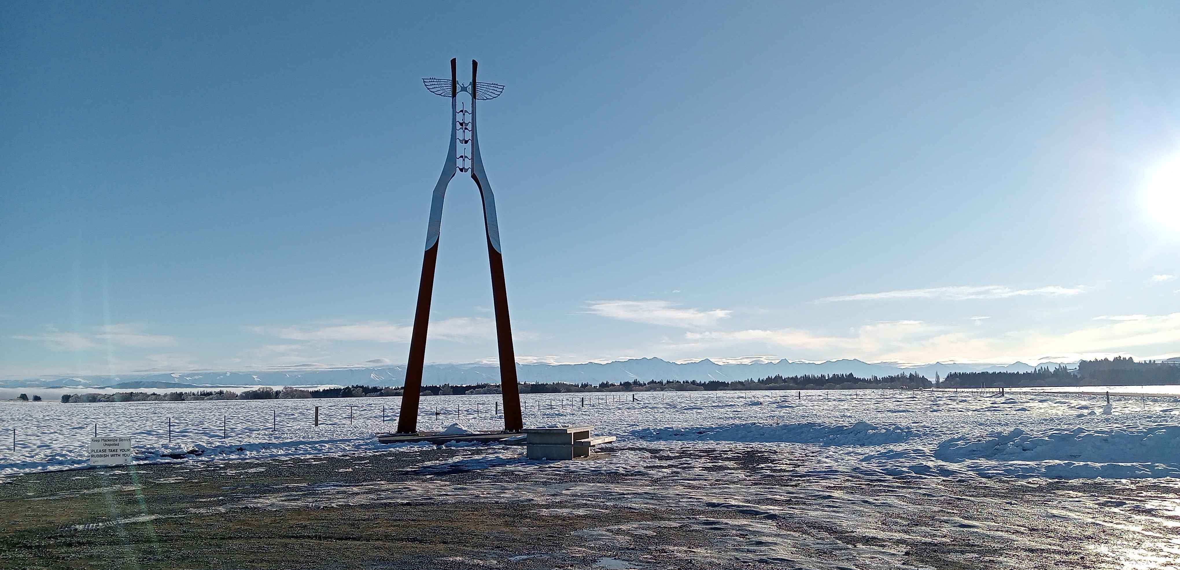
Near Burkes Pass, there is also a brand-new Māori cultural monument, which celebrates the role of Te Kopi o te Ōpihi (Burkes Pass) as the gateway to Te Manahuna and its mountains and lakes. The monument consists of a winged tower and several other installations.
And then on back to Twizel through Lake Tekapo, home of the largest Gold Standard Dark Sky Reserve in the world. This is something you discover on the website of a museum of astronomical experiences and observatory in Tekapo, called the Dark Sky Project.


From this spot, you can also catch a glimpse of the famous stone Church of the Good Shepherd, right in the middle of the next photo, though you have to look fairly hard.

There is another, more powerful observatory atop nearby Mount John, to which the Dark Sky Project runs tours. Meanwhile, close to the Dark Sky Project, there is also a pedestrian bridge over the Tekapo River, which carries the outflow from Lake Tekapo to a succession of hydropower stations that give a new twist to Te Manahuna.

Near the pedestrian bridge, Chris also filmed some ducks eating apples under a gnarly tree.
For more on this area, see my posts on Aoraki/Mount Cook and the Foothills of the Alps.
Next week, I’ll have a post about the Lindis Pass, which is on the way back to Queenstown from Te Manahuna. I’ll be writing about Ōmarama once more, and about the Clay Cliffs nearby, and exploring the ruins of the old Lindis Pass Hotel.
If you liked this post, check out my book about the South Island! It’s available for purchase from available from my website a-maverick.com.


Subscribe to our mailing list to receive free giveaways!
