Giveaways
I’VE just begun a tour of another country that I’ve long wanted to visit. Namely, the Republic of the Philippines. I’m in Manila, the nation’s capital. Manila is on Luzon, the northernmost big island in the Philippines and also the most populous.

I flew from Auckland to a hub airport in China, and then caught another flight southward over Taiwan and northern Luzon to land at Ninoy Aquino International Airport. From the airport, the Manila Metro Rail Transit System (MRT) runs downtown and to other destinations in the Manila metropolitan area.

For the first few nights, I stayed in Makati City, between the airport and downtown Manila, in a well-regarded hostel called BuenaSentro.
BuenaSentro only cost me 2,100 pesos for four nights. One New Zealand dollar is worth about 30 to 35 pesos. So BuenaSentro was cheap as chips.
When I was in Makati, I did a lot of walking. Indeed, the very night I arrived, I met a guy from Hungary (or Bulgaria), and he said to go down to the waterfront and see the fireworks.
Here is a video I made, of scenes filmed across my first few days in Metro Manila. It starts with a ride on a sort of electric tuktuk through the streets of Makati, in which I comment that the chaotic-looking streets are surprisingly safe, in the sense that there are so many pedestrians that drivers usually stop for them.
That scene is followed by a wander along the nearby waterfront that I was told to visit, except that I found it was mostly fenced off for some reason.
And then a visit at sunset, on that first day, to a publicly accessible part of the waterfront to view the fireworks. Unfortunately, perhaps as a result of the fencing off of the rest, this part of the waterfront turned out to be very crowded!
But I got a great view of the sunset over the bay. I also ended up at a Korean barbecue restaurant, which was amazing. I stayed there for three hours and then took a taxi back, because I was stuffed!
Apparently, many Koreans retire to the Philippines because it is cheaper than retiring in Korea.
After Makati, I moved downtown to the White Knight Hotel. Properly known as the White Knight Hotel Intramuros, the White Knight is within the old Spanish walled city of Manila, now called Intramuros.
Intramuros sits below the name of Manila on the map, above and between Fort Santiago and the National Museum of Fine Arts on the following map, which is more zoomed in.

The White Knight cost 13,000 pesos for five nights. But I was celebrating my birthday — so, why not!
The Philippines has about 150 million inhabitants. Luzon has 74 million people, which makes it about the third most populous in the world.
I spent my first few days just walking around and getting my bearings. I gravitated toward Rizal Park, the city’s premier downtown park, where the National Museum of Fine Arts and the National Museum of Anthropology and the are located on the Agrifina Circle, home to several notable museums and gardens.

Rizal Park is named after the national hero of the modern Philippines, José Rizal. It is located right next to the old town Intramuros (Spanish for ‘inside the walls’), a historic area that is an absolute must for heritage fans.
Here’s a photo of the San Augustin Church in the Intramuros district, one of four Filipino churches making up UNESCO’s Baroque Churches of the Philippines World Heritage Site.
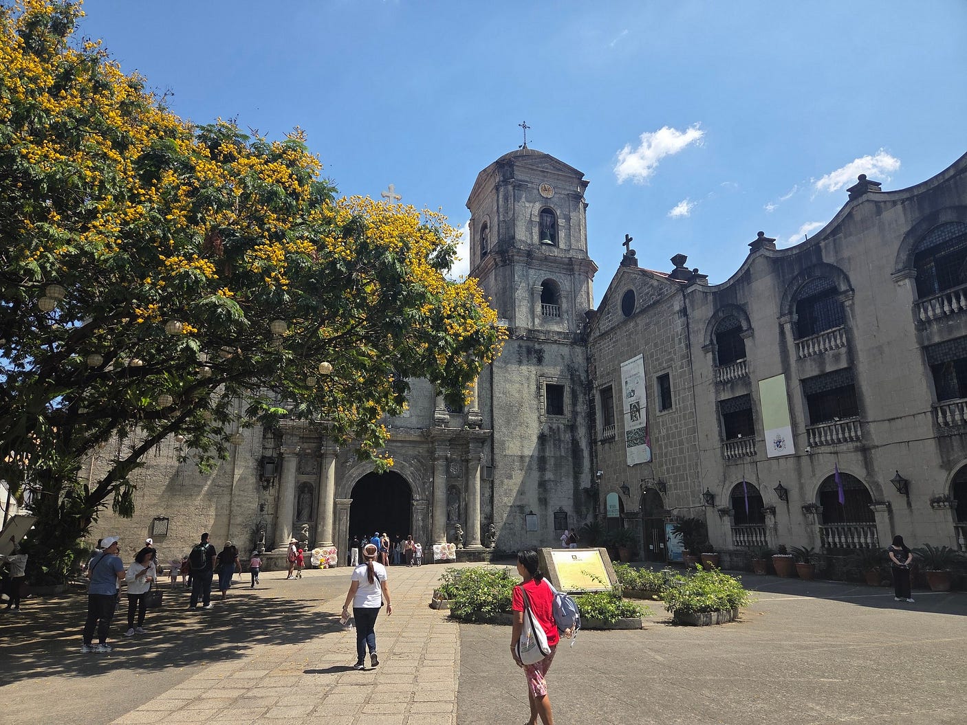
San Augustin is the oldest stone church in the Philippines, completed in 1607.

San Augustin is also famous for its ornate wooden door, carved from a tropical hardwood called Molave.

Despite its magnificence, San Augustin is not the cathedral of Manila. The next photo shows the quite separate Manila Cathedral, which has been rebuilt eight times since 1581 as a result of earthquakes, fires, and the destruction of the Intramuros district in World War II, of which more in my next post, by night.
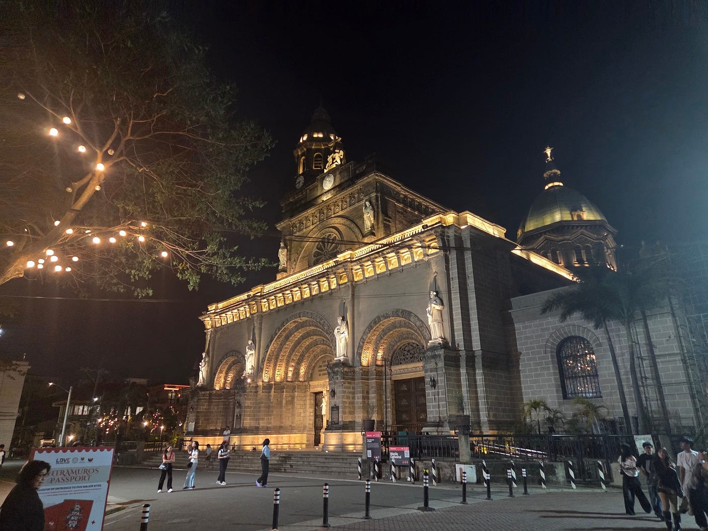
Here is a photo taken inside the Manila Cathedral in the daytime.

At the bottom left of the night-time photo, you can see a sign advertising the Intramuros Passport, an information booklet that, for 350 pesos, also gives you free access to key attractions in Intramuros.
Here is a photo of myself taking a break on a fountain near one of the tunnels of Fort Santiago, which you can see in the background.

And here is a photo of General Luna Street in the Intramuros, in which you can see a sign advertising the Intramuros Tourism Centre, next to the first couple of letters of another sign advertising Barbara’s Heritage Restaurant, over the entrance to an arcade that I was able to walk through to get to the White Knight Hotel Intramuros.

And here is a video I made. I start with a walk into the arcade in the photo just above, and then explore Fort Santiago and the San Augustin Church, before dining at Bloque 7 Cafe.
I should emphasise that not every part of Manila is old and colonial-looking. Like most cities, Manila has grown hugely since 1900, and much of the new city looks just as modern as anywhere else.
But getting back to history, the Philippines were colonised by Spain from 1565 to 1898, a period that left a huge imprint. The very name ‘Philippines’ honours Philip II, the King of Spain from 1556 until 1598, who thus presided over the founding of the Spanish colony in the Philippines: the same Philip was the adversary of England’s Elizabeth I, the one who sent the Spanish Armada to England in 1588.
The Spanish founded their city of Manila in 1571. That is usually regarded as the date when Manila was founded although, in reality, a Tagalog settlement called Maynila had existed on the site for centuries beforehand. For a long time, thereafter, Spanish Manila was limited to the walled city now known as Intramuros.
The Spanish integrated the Philippines into an hourglass-shaped network of galleon trade routes that spanned the Pacific and the Atlantic. Galleons were armed merchant ships, stuffed with gold and spices and other exotic Oriental and American treasures.

If any pirates turned up, the galleon would blast away at them. This usually sufficed for pirates of the ordinary sort, though the greatest pirates of all, the Elizabethans, were not so easily swatted away.
The Panama Canal did not yet exist, so the Spanish had to carry their precious cargoes overland between Acapulco and Veracruz in Mexico, a portage that formed the neck of the hourglass. The galleons sailed westward on the tropical trade winds, which blow from east to west, and eastward on the westerlies of the temperate latitudes.
Before the Spanish, who converted most of the archipelago to Catholicism and the Latin script, the Philippines were mostly Muslim, and wrote in scripts descended from Indian forms of writing, such as Baybayin.

The language that used to be written in that script, Tagalog, exists today in a standardised and official form known as Filipino (which is also the term for people from the Philippines).
Filipino, the language, is closely related to Malay, Bahasa Indonesia (a slightly different variety of Malay spoken across Indonesia as the official language of the nation), and Javanese, the traditional language of Java.
All those languages belong to a family called Austronesian (meaning ‘of the southern islands’), and, specifically, to its Malayo-Polynesian branch, a branch that includes Māori.
Expert seafarers, the Malayo-Polynesians roamed far and wide from their original homeland of Taiwan, settling wherever there were Pacific islands to settle.
Malayo-Polynesian roamings help to explain why, even in Japan, there are, apparently, more than a hundred words that are similar to Maori ones for the same thing; words most likely implanted by Malayo-Polynesian settlers whose descendants became assimilated into the more numerous Japanese but left a few of their expressions behind.
Among the Malayo-Polynesian languages, the similarities are even greater. This is because the Malayo-Polynesians expanded out of Taiwan just a few thousand years ago.
Thus, the Tagalog say bankga (canoe), the Māori of Aotearoa (New Zealand) say waka; the Malays say bukit (hill), the Māori say puke (pronounced pukeh)
In Malaysia, Māori soldiers stationed there in the 1950s and 1960s found that they picked up Malay very quickly.
Another thing Austronesian peoples seem to have in common is a fondness for elaborate wood-carving. This example, which looks like a miniature Filipino bangka, does not look too different to a Māori ceremonial waka.

On the larger islands that the Malayo-Polynesians colonised, there were often indigenous peoples. Among the most widespread surviving groups of indigenous people in the Philippines and neighbouring island groups are the Negritos, a Spanish word meaning the little black ones.
Like the Australian Aborigines, the Negritos seem to be an ancient people, or group of peoples for they may have several origins, dwelling in the Philippines and neighbouring island groups for tens of thousands of years.
As with the later Malayo-Polynesians, the Negritos and other indigenous peoples must have arrived on seaworthy boats steered with skill, since, even in the Ice Age when sea levels were lower, voyages to many of the islands settled by Negrito peoples, and Australia, required sailing beyond the horizon.
Of course, the details of how the indigenous peoples sailed to the islands are now lost in the mists of time, whereas the navigational feats of the Malayo-Polynesians are well known.
Before the coming of the Spanish, the Malayo-Polynesian majority in the Philippines was linked by trade to its cousins in modern-day Malaysia and Indonesia, and to Vietnam, Thailand, and China as well.

From China, merchants also fanned out along the same trade routes to form communities of overseas Chinese that remain strong to this day, and even the majority in such places as Singapore.
Next week, I will take you to some more of the sights of Manila. I will have travel tips based on experience as well.
Subscribe to our mailing list to receive free giveaways!
