Giveaways
IN September, I put out a post called ‘From Kerikeri to Karikari’. It was part of a series about a journey around part of the North Island of New Zealand that lies to the north of Auckland.
I had meant to publish these one after the other, but kept getting sidetracked with posts about Sāmoa, Australia’s Northern Territory, and many other places!
Well, this week, my journey around the ‘winterless North’ resumes, in the form of a trip all the way up to Cape Rēinga and back.
Cape Rēinga is where the spirits of the deceased were said to jump off and return to Hawaiki, the spiritual origin and place of return of the Māori.
I love heading up to Cape Rēinga, which is scenic as well as spiritual. The journey reminds me of the most famous lines from the Scottish lament, Loch Lomond,
You’ll take the high road and I’ll take the low road,
And I’ll be in Scotland afore you.
State Highway 1 is the high road, the spiritual pathway the low road.
A year ago this December, an incredibly wet month that foreshadowed the great rainstorms of 2023, I had planned to drive to Cape Rēinga via State Highway 1.
But the Mangamuka Bridge, at the head of the Hokianga Harbour, was closed by a slip. So, I had to divert around the Bay of Islands on the east coast and State Highway 10. This was no hardship really, as you can tell by reading From Kerikeri to Karikari and several of the other posts about this journey.
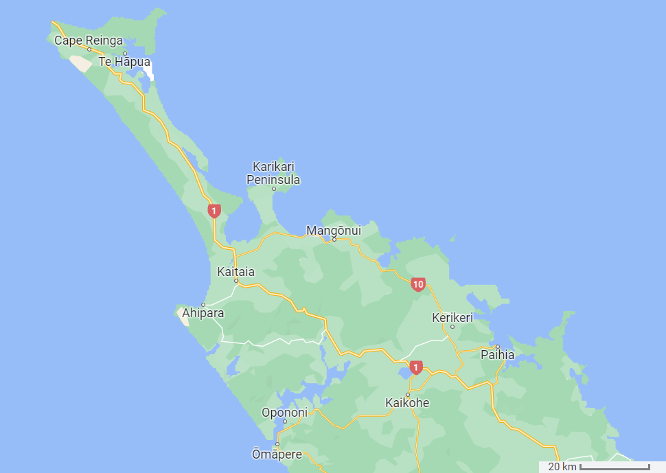
Rejoining State Highway 1 after the Karikari Peninsula, I headed to Cape Rēinga. This involved travelling up the Aupōri Peninsula: the final neck of land before you get to Cape Rēinga and the large headland known as Te Paki at the northern end.
The sign in the following photo shows the Aupōri Peninsula in the form of the long, thin neck of land that begins west of the Karikari Peninsula and extends northward to widen into Te Paki at its very northern tip.

Once on the peninsula, the first place I stopped was at Houhora Heads, the entrance to Houhora Harbour.

The next two photographs were taken at Houhora Heads. I wasn’t getting much sunshine on this trip, but on the other hand, I suppose that also made it more atmospheric.

Indeed, Māori cultural artifacts are probably best seen on misty days.

On a less reverent note, Houhora also claims to have the northernmost pub in New Zealand.
The other side of the Aupōri Peninsula is dominated by Te Oneroa-a-Tōhē, which literally means the long beach of Tōhē, a notable northern chief who lived during the early days of Māori colonisation of Aotearoa.
Tōhē was responsible for more than one hundred placenames in the north, both those which he named and those named after him.
Tōhē’s lengthy beach is known in English as Ninety Mile Beach, a notoriously inaccurate name for in fact, the beach is only about 90 km long, or 56 miles. Still, that is pretty impressive.

You can do bus tours from Kerikeri, Kaitaia, and Paihia along Ninety Mile Beach, all the way to Cape Rēinga. It pays to shop around as they have different bundles of activities. Operators include Fullers, Dune Rider, and, until the recent tourism downturn, Harrisons (which might revive in the future, I suppose).
A good place for local access to Ninety Mile Beach, if only because it is handy to the last pub, is the Hukatere Lodge and Camping Ground, on the western side of the Aupōri Peninsula. It is also right next to a section of the Aupōri Forest.
Another good place to stay in this area is the North Wind Lodge Backpackers, a little further north on the eastern side of the peninsula. There is a basic but excellent free travel map of the district that you can download from their website.

Also on the eastern side, a bit further north still, lies Rarawa Beach. It is said that Rarawa Beach has the whitest sands, and therefore the most turquoise waters, of any beach you can easily get to in New Zealand. And a well-serviced campsite.


I only found out about the attractions of Rarawa Beach after I came home, so I am kicking myself that all I did was take a photo of the roadsign. Next time!
The New Zealand Department of Conservation (DOC) page on the Rarawa Campsite is here. It currently costs NZ $16 a night, and you have to book. The booking link takes you to a website called rarawacamp.nz. This belongs to a Māori incorporation, the Ngāti Kuri Trust, which is actually in charge of running the Rarawa Campsite and two others further north in the Te Paki area, as well.

For somewhat more swept-up accommodation at Rarawa Beach, you can stay at the Wharekapua Beach House. This is typically around NZ $799 for three nights.
North of the turnoff to Rarawa Beach, past the village of Te Kao (where there is another road to Ninety Mile Beach), you come to a larger natural harbour called Parengarenga Harbour and, by a small detour, the township of Te Hāpua, from which Whina Cooper set off on the famous 1975 Land March to Wellington.

Parengarenga Harbour is protected from the open ocean by a spit of almost chemically pure white sand, similar to the sand at Rarawa Beach, called Kokota Spit. Kokota Spit used to be mined for glassmaking, but fortunately, those days have ended. You need special permission to cross Māori land to get there.
Te Paki, the general widening of the land at the northern end of the Aupōri Peninsula, was once an island. The thinner part of the Aupōri Peninsula is a tombola, a natural causeway formed by sand buildup between two islands or an island and the mainland.
A portion of Parengarenga Harbour appears on the right-hand side of the sign labelled ‘Te Paki Recreation Reserves Visitor Information’, just below. As you can see, there are lots of tracks, although some of them are closed, as of the time of publication, because of lingering damage caused by the rainstorms (more on this below).

Cape Rēinga, which has sported a lighthouse since 1941, really does feel like the end of the line.

The Tasman Sea and the Pacific Ocean meet there, in great swirls of sometimes different-looking water.


The following are signs of welcome, in English and Māori.

The next sign gives an account of how the spirits head home to Hawaiki, from which the fiftieth US state also gets its name, though the two names do not mean exactly the same thing.

In Polynesian tradition, the original Hawaiki is a sort of lost Eden to which spirits head home after death in the material world. Perhaps it is a myth that comes naturally to a voyaging people. Another sign I came across reads thus:
Descending to the underworld
The rocky point jutting out to sea is Te Rērenga: the place where the spirits enter the underworld.
Clinging to the rock there is the ancient kahika tree, named Te Aroha. The spirits descend to the water on steps formed by the tree’s roots. They then continue on their journey to Hawaiki, the spiritual home.

Here is a photo of Te Rērenga, which means the jumping-off place. It is also indicated on maps as Te Rērenga Wairua, the jumping-off place of the spirits, a name that is also used synonymously with Cape Rēinga, as they are in fact in the same place.

This weathering steel plaque describes the sacred tree at the tip of Te Rērenga in a little more detail.

Another Maori belief that might sound familiar to others is a version of the waters of Lethe:
The name of the other spring is Te Wai Whero o Rata. If the spirit drinks the spring’s water, they will carry on to the spiritual world. If not, they will return to the land of the living.

Expected behaviour of visitors includes no eating or drinking near the most sacred sites.
Another signboard relates a tale about Tōhē, by which one of the two traditional Māori names of nearby Spirits Bay arose. This name is Kapowairua, meaning ‘catch spirit’, the other Māori name being Piwhane.
Tōhē dwelt in a village beneath the hill of Maunga Piko, close to the present Kapowairua (Spirits Bay) Campsite. You can see Maunga Piko toward the right of this photograph of the beach in front of the campsite.

The next photo shows a panorama of Kapowairua from Murimotu Island at its eastern tip, itself accessible by a tombola at low tide.

In his great old age, Tōhē set out for the Kaipara Harbour to visit his only daughter Rāninikura one last time. This was some 250 km to the south. Tōhē was frail by this stage, and his people implored him not to go lest he die far from his tūrangawaewae: his home, hearth, and relations. Indeed Tōhē did perish on the way, at Whāngaiariki near Maunganui Bluff.
Tōhē himself had feared that this might happen. And so before leaving, never to be seen again, he asked the people of his village to catch his spirit as it passed by on the way to Te Rērenga and Hawaiki, and trap it forever at Maunga Piko instead.

I felt that some of the signage could stand to be replaced, considering the significance of the locality. It’s not only spiritual and scenic but drastically exposed to the elements.
The wood wasn’t going to be readable much longer and even the weathering steel, which is meant to rust a little bit, looked rusted full stop.
Te Paki has had some problems with stray dogs, problems that led to a precautionary track closure, which some people regarded as an over-reaction, in 2021.
Although this may now have been dealt with, the area was then hammered in the storms of 2023 and had a big fixup thereafter, with prolonged closures, described as follows in a Department of Conservation notice that appears on NZ Tramper and other sites, as of the time of writing:
Due to safety issues caused by recent weather events, all walking tracks east of State Highway 1 and Cape Reinga/Te Rerenga Wairua in the Te Paki Recreation Reserve are closed. The tracks to the west including the Lighthouse track are open.
Pandora campsite is closed. Tapotupotu, Kapowiarua (Spirits Bay) and Twilight campsites are open.
First published on 28 March 2023. Last reviewed on 7 December 2023.
There were some further reopenings as of 12 December 2023. So, perhaps the signs were upgraded at the same time.
In any case, the gradual reopening is another good reason for me to be putting up this post right now!
Here are some more scenes from Te Paki. First, Cape Maria van Diemen, at the western end. This is the same van Diemen family that had its name bestowed on van Diemen’s Land, as Tasmania was known in convict days.

The following photograph shows Cape Maria van Diemen and Motupao Island, with part of the western, still-open section of the Te Paki Coastal track visible on the top of the cliff in the middle of the picture. Motupao Island was the site of the local lighthouse from colonial days until the present one was built at Cape Rēinga.

Here is another photo of the cape from a site closer to its tip, showing small rocky islands and another tombola.

Cape Maria van Diemen and the nearby Three Kings Islands are the only two placenames originally bestowed by the seventeenth-century Dutch explorer Abel Tasman that are still officially in use in New Zealand.

The following information panel, above a dramatic cliff, explains how the Three Kings are an important nature sanctuary.

Each of the extreme ends of New Zealand’s two main islands has a cluster of signs. The sign at Cape Rēinga says that it is 1,452 km to Bluff, where the other great cluster of signs is to be found, at the far end of the South Island.

Here’s a photo of myself at Bluff, by the way. As you are 1,452 km closer to Antarctica, summer beachwear is a bit different down there!

Zooming back to Te Paki, I have to say the tsunami evacuation signs put me off camping right on the beach!

This time around, I didn’t visit the giant Te Paki sand dunes.

I do talk about them, however, in one of my earlier posts, called ‘Spirits Bay and Sand Duning’.
I’ve also just remembered that there is an excellent library of usable images of the northernmost parts of New Zealand, courtesy of the NorthlandInc Media Centre. I got the image of Rarawa Beach from this source, and I’ve also used several more in a social media video that I made to publicise this post, on 29 December 2023. I might add some to my other Northland/Te Tai Tokerau posts, which also suffered from dismal weather, as well.
If you liked this post, check out my award-winning new book about the North Island, available from my website a-maverick.com.

Subscribe to our mailing list to receive free giveaways!
