Giveaways
EVERY now and then I drive from Queenstown to Invercargill — known as ‘Invers’ to the locals — to get bits and pieces for my car, to go shopping, or to get a pedicure, as Queenstown is notoriously expensive for personal services.

Invercargill is not just the southernmost city in New Zealand, but the southernmost of all the cities where English is the main language, in the whole world.
On one of my trips down there, I set off on the 18th of January, which is high summer here. The day was gloriously warm. But the next two days became wrap-up days, as they often are at the south end of New Zealand even in summer.
Up to now, Invercargill has been overshadowed by flashier and more adventuresome tourist destinations like Queenstown, famous for things like bungy jumping and skiing as well as the undoubted charms of Lake Wakatipu.
But Queenstown seems to be full up, and overpriced. Many backpackers and freedom campers are also being driven out of Queenstown and its restrictive environs.
The fortunes of old-fashioned and off-the-beaten-track places like Invercargill often improve when people get tired of the Queenstowns of this world, and go looking for a more relaxing sort of holiday.
Invercargill might not do bungy jumping and skiing, but it’s still the gateway to the wilderness of southern Fiordland where the Hump Ridge Track is located; the coastal wilderness of the Catlins east of the city; the lengthy beaches of 26-km long Oreti Beach where Burt Munro used to race ‘The World’s Fastest Indian’ and the similarly lengthy beaches of Te Waewae Bay and Toetoes Bay; the town of Bluff (most southerly on the New Zealand mainland); Slope Point, the southernmost point on the South Island; and Stewart Island/Rakiura further to the south, a large island that is now one of a handful of international Dark Sky Sanctuaries.


Invercargill also has a lot of beautiful old buildings and parklands, which I’ve written about in an earlier post.
The large, classy Queens Park joins on to a so-called Town Belt of parkland that encompasses the inner city. The Town Belt is shaped like a trident with Otepuni Gardens, through which flows the Otepuni Stream, as the middle prong. The downtown area is thus divided up into two precincts in an arrangement very similar to the Adelaide Park Lands, except that in the case of Invercargill, the railway yards and the industrial district of West Invercargill (probably still a swamp in the 1800s) form the western side of the downtown precinct.

Such encompassing parklands were a common thing in colonial New Zealand and in some towns and cities in Australia too, such as Adelaide.
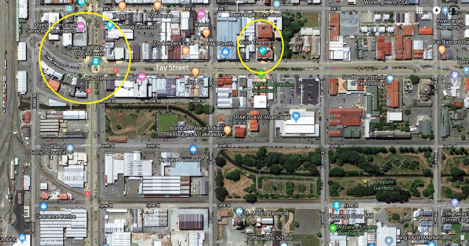
Here’s a more detailed aerial photo of a part of the central area, followed by a historical photo and some photos of my own taken inside areas highlighted with yellow ellipses. You can see the Otepuni Gardens and stream in this aerial photo, as well.


All in all, old colonial cities like Invercargill (and Adelaide) often have a lot of character and public amenity, and need to be kept that way.
On the other hand, anything to do with petrol and motor racing is a big thing in Invercargill, thanks to the influence of people like Burt Munro no doubt. Or to put it another way, Burt Munro didn’t race up and down Oreti Beach all by himself. I went to Teretonga Park, the home of (non-beach) motor racing in invercargill and its surrounding region, which is known as Southland.
There’s also Transport World, an absolutely world-class double transport museum founded by the late H W [Bill] Richardson, a prominent Invercargill trucking company proprietor and obviously passionate enthusiast for anything that ran on rubber; one of those people who had Diesel for blood, as you might say. Bill Richardson’s company now has the more corporate-sounding name of HWR and has, indeed, since diversified into real estate. More on that later.
There are two individual museums on the Transport World site, Bill Richardson Transport World, which bills itself as “the largest private automotive museum of its type in the world,” and Classic Motorcycle Mecca, which claims to be “Australasia’s premiere motorcycle museum.” To call something Mecca might not be regarded as too woke in a more cosmopolitan sort of a city — one or two Auckland cafes had to drop that name — but then again Invercargill really is a wind-your-watch-back-thirty-years sort of a place.
Which raises an interesting point. Invercargill has started to change in recent years.
Tourism is up in Invercargill (as is homelessness), and Airbnb is catching on too.
The Southland Museum and Art Gallery in Queens Park has closed due to earthquake risk, pending redevelopment. And earthquake risk, and the cost of refurbishment, was also used as a pretext to demolish almost the whole of Invercargill’s oldest and most historic city block, between Tay, Dee, Esk, and Kelvin Streets, across the way from the Crescent and the South African War Memorial.
Here’s a video of me walking around the area and looking at the frontages. The buildings across the road that I wonder about at the end, are safe.
I had quite a bit to say about all that in a couple of other posts called ‘From Heritage, to Glass and Girders?’ and Invercargill’s New Mall.
It was on Saturday the 19th, when I was shopping for sandals, getting a pedicure and looking for car parts, that the locals I ran into told me about their ‘crazy’ council-sponsored redevelopment scheme.

Like just about everyone who isn’t from Invercargill, I’d heard or noticed nothing about it till I went there and met local people. It’s amazing how much can go on in a town without anybody who doesn’t actually live there ever finding out about it, even in the modern information age.
On the Saturday, I also managed to make enough time to get to Queens Park, where I caught up with about 100 runners from a club called Invercargill Parkrun. This seems to be an arrangement whereby busy people work towards a competitive race around the park once a month. I met a woman who was a marshal, guiding the direction of the run.


We spoke for 20 minutes. Her name was Marie and I found that I had met her socially eight years before, a friend of a friend. Her husband Ant was also a Facebook friend of mine, as it turned out. We ended up going to the park’s gilt-edged-service café, the Cheeky Llama, and talking more about the redevelopment scheme and other things.

The next day, a search for a second-hand bumper for my car led to a place called Demolition World, run by another woman named Leigh, which turned out to have nothing to do with car parts at all. Instead, it was a re-created town made up of bric-a-brac from the colonial era to the 1960s, stuff that Leigh saved while onselling more valuable recycling materials, timber mostly.
One of the old signs outside the front entrance promised panel-beating services, so I thought it must be an auto junk yard. It turned out that it was just a sign and that Leigh was a sign collector.

I was so astounded. Demolition World has 50 shops which recreate the past, a church where people are getting married in the old style; a bar with old style bottled beer; a ‘dairy’ (NZ expression) or corner shop from the fifties with 1950s containers for the products; a circus; a shop with old toys; a blacksmith’s shop; a railway station; and old horse-cart; and an old medical centre. It’s a work of art.


Leigh, who has seven children, doesn’t charge other than a ‘gold coin’ donation (meaning $1 or $2, not real gold).
Then, finally, I went off to Bluff to climb Bluff Hill and take some more photos. Though isolated and remote even by New Zealand standards, and completely at the wrong end of the country as far as the rest of the world is concerned, Bluff is nevertheless a surprisingly important port. Part of the reason for this is that it serves the Tiwai Point aluminium smelter, a plant that uses cheap, possibly undervalued, hydroelectric power to smelt some of the world’s purest aluminium. Tiwai Point was commissioned in 1971. I think in those days the politicians had a vision of New Zealand as the Sweden or Switzerland of the South Pacific, making expensive added-value products such as racing bike components out of the aluminium. But these days, 90% of it is exported as ingots.
Bluff has some attractive buildings of its own, such as the one that is now the Bluff Lodge.


Bluff is a place that people visit to relax, since it is literally at the end of the line.

Bluff Hill is officially Bluff Hill / Motupōhue, of which the Māori name means 'isle of vines'. It isn’t quite an island, as you can see.


There’s a link to the walks on Bluff Hill here.
By the time I got to Bluff the January weather had turned into the opposite of summer, as it often does in these parts, which lie in the latitude of Patagonia and face south toward Antarctica.
(The attractions of Bluff are a bit like Britain’s famous ‘Skegness is so bracing’ tourist poster, which makes the best of a place that can’t exactly claim to be the Riviera. So it is for Bluff and Southland in general, even though this part of the country has stunning beaches that would attract millions if only they were in a balmier location.)

Here I am beside a famous sign.

The weather was a bit better on another occasion, however. I wouldn’t want to give the impression that it is always terrible!

The views from the top are fantastic, though a truly clear day seems to be rare.


Bluff is the oldest settler town in New Zealand: two hundred years old this year.

There were information panels on the wildlife of Bluff Hill, both present and extinct.

And there’s an old gun emplacement on the hill, created just in case anyone ever tried to attack the most southerly trading port in the British Empire and work upwards toward London from there (they didn’t).


Plus, there’s also significant Māori culture on the isle of vines. Although South Island Māori faced a harsher environment and were fewer in number than in the North Island, this area is known for its fat juvenile seabirds, known as tītī or muttonbirds, which would be regularly harvested and preserved and thus helped to sustain human life.

Finally, this is me trying to narrate a video about the view down to the town of Bluff and the Tiwai Point aluminium smelter.
But do come to Bluff — it’s so bracing!
There’s more about this part of the country in one of my books, The Sensational South Island, on sale on my website a-maverick.com.


Subscribe to our mailing list to receive free giveaways!
